Scan to Download
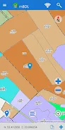
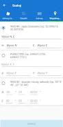
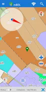
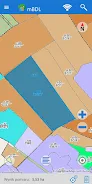
The mBDL app, short for Mobile Forest Data Bank, is a user-friendly application that provides direct access to forest maps on phones and tablets. With various forest thematic BDL maps, such as tree stands, ownership forms, hunting maps, and more, users can easily navigate and explore forests. The app also offers the option to display raster backgrounds, including topographic or aerial/satellite orthophoto maps, and connect to external WMS services. Even when offline, users can download forest district and national park maps for offline use. Additionally, the app provides a full taxation description for forests, including detailed information on species, economic indicators, and more. With functional features like area and distance measurement, GPS recording, and route navigation, users can efficiently navigate through forests. The mBDL app also allows users to export and import saved waypoints and routes. Get the mBDL app today and start exploring forests like never before! Download it from here: https://www.bdl.lasy.gov.pl/portal/deklaracja-mbdl.
Features of this App:
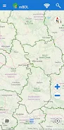
- Direct access to forest maps on phones and tablets.
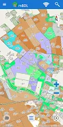
- Forest thematic BDL maps, including basic map, treestand, ownership forms, forest habitats, plant communities, hunting map, tourist development map, and fire hazard map.
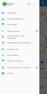
- Option to display predefined raster backgrounds like topographic maps or aerial/satellite orthophotomaps.
- Ability to connect to external WMS services by entering a specific URL address.
- Mechanism for downloading data for offline work, allowing the use of maps in forest districts and national parks.
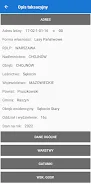
- Online access to a full taxation description for forests of all ownership forms, including species of trees and shrubs, forest address, economic indications, and other information.
Conclusion:
The mBDL App provides convenient and comprehensive access to forest maps and data. Users can easily view and navigate through various forest thematic maps, including information on ownership forms, habitats, and more. The ability to connect to external WMS services expands the range of available map options. The app also includes offline functionality, allowing users to access maps in areas without an internet connection. Additionally, the app provides a detailed taxation description for forests, making it a valuable tool for forestry professionals and enthusiasts. With features like area and distance measurement, GPS recording, and navigation, the app offers practical functionalities for users in the field. The inclusion of a help menu and manual ensures that users can quickly familiarize themselves with the app's functionalities. Click the provided link to download and experience the convenience and richness of the mBDL App for yourself.
File size: 74.00 M Latest Version: 1.19.1
Requirements: Android Language: English
Votes: 69 Package ID: pl.gov.lasy.bdl

Explore the world with confidence using our intuitive map software. Navigate unfamiliar cities, find hidden gems, and plan adventures with ease. Our powerful apps feature robust offline functionality, real-time traffic updates, and crowd-sourced points of interest. Customize maps to match your needs - save favorite locations, download areas for offline access, and share recommendations.


LIVE A HERO
Retro Hero Mr Kim
Empire of Passion
Arcane Quest Legends
Magic Snap: Momotaro
AllStar Manga Heroes
Lunescape
ONE PIECE Thousand Storm JP
Tap Titans 2