Scan to Download
The Alabama Forestry Commission mobile app brings essential forestry resources, fire-safety alerts, and practical land-management tools into a single, easy-to-navigate package. The Alabama Forestry Commission app is intended for landowners, consulting foresters, and members of the public who need timely information about wildfire risk, state guidance for timber and woodland care, and quick access to local office contacts. This editor summary explains how the app organizes information, what to expect from its controls and workflows, and how it supports everyday stewardship decisions.
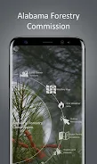
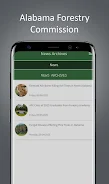
At its core the app integrates region-specific fire alerts, a searchable resource library, and map-based views that show county and district advisories. Fire notifications use simple risk levels and timestamps so you can judge currency at a glance. The resource library gathers official guidance documents, best-practice checklists, and contact details for district foresters. Map layers can be toggled to reveal nearby infrastructure that affects response times and to visualize localized risk zones without overwhelming the main display.
Controls follow familiar mobile patterns: tap to open alerts and documents, pinch and drag on maps, and straightforward forms for saving property details or notes. Notification toggles and location filters are prominent and predictable, letting users set county- or district-level preferences quickly. Tooltips and contextual help are embedded in the interface to shorten the learning curve, and the most commonly used actions are reachable in two or three taps to keep interaction fast and safe when working outdoors.
The app emphasizes practical progression rather than gamification. You can save multiple property locations, record stewardship activities such as prescribed burns and thinning operations, and maintain a simple task inventory to track follow-up work. These entries build a private log that demonstrates ongoing maintenance and stewardship over time, helping users prepare management plans or document actions for regulators and consultants. Progress is measured by the usefulness of records, not points or rankings.
Design choices favor clarity in field conditions: high-contrast type, readable icons, and layered maps that make administrative and ecological 'levels' — county advisories, district alerts, and localized risk areas — easy to distinguish. Document views present concise headings with the option to expand into full guidance so readers can skim key points and dive deeper when necessary. Color and icon cues are reserved for urgency and status indicators to avoid visual clutter during routine checks.
Notification settings are flexible so you receive only the advisories relevant to your properties or interests, and you can set quiet hours for non-urgent messages. The app offers basic offline support by allowing essential maps and documents to be cached for field use; cached items show the last update time and refresh automatically when a connection is restored. These features make the Alabama Forestry Commission app useful in remote areas where connectivity is intermittent.
Accessibility features include adjustable text sizes, a high-contrast display mode, and plain-language summaries for essential guidance to help a broad audience understand recommendations quickly. The interface minimizes clutter and uses clear headings so non-specialists can navigate content efficiently, while technical references and links to in-depth state resources remain available for professional users who need more detail.
The app’s ongoing value comes from regular use during high-risk seasons, preparation for timber operations, and quick checks before prescribed burns or community outreach. It encourages repeat engagement through updated advisories and practical checklists rather than competitive mechanics. Because official notices follow agency reporting schedules, some local incidents may appear after a short delay; the tool is designed for planning and situational awareness that complements on-the-ground assessment and coordination with emergency services.
While the Alabama Forestry Commission app consolidates statewide guidance and makes it easier to reach official materials, it does not replace professional field inspections or emergency responders. The app is focused on Alabama conditions and has limited relevance outside the state. Users should verify any critical information directly with local forestry offices or emergency agencies when immediate action is required, and treat the app as a planning and information resource rather than a definitive operational command system.
File size: 25.70 M Latest Version: 2025.7.5
Requirements: Android Language: English
Votes: 270 Package ID: com.civicapps.alabamaforestrycommission
Developer: Tyler Technologies, Inc


Must Have Tools Apps for Android
Equip yourself with our all-in-one toolbox app for everyday tasks and projects. Instantly convert between units, calculate tips, scan documents, manage files, and more with handy productivity tools. Includes a level, compass, QR code reader, ruler, speedometer, decibel meter, and flashlight. Save frequently used tools to your customizable dashboard for one-tap access. Track billable hours, wages, budgets, and invoices. Annotate screenshots, magnify labels, and sign PDFs on the go.


LIVE A HERO
Retro Hero Mr Kim
Empire of Passion
Arcane Quest Legends
Magic Snap: Momotaro
AllStar Manga Heroes
Lunescape
ONE PIECE Thousand Storm JP
Tap Titans 2